
While we experience our cities in 3D, how we have visually made sense of and planned them has traditionally been in 2D through maps, plans, and spatial models and statistics. When we have visualised cities in 3D as architectural drawings or photographs it has largely been from fixed views from particular vantage points. These limitations are in the process of being overcome through the development of new 3D geospatial technologies such as virtual reality (VR), augmented reality (AR), building information modelling (BIMs), city information modelling (CIM), and the creation of new 3D spatial data such as lidar scans and 3D models digitised from stereoscopic images. These technologies and data have the potential to significantly disrupt administrative, planning, architectural, construction and real-estate practices, by enabling users to immerse themselves in, explore, interact, query, and experiment with spatially-intelligent virtual environments, or to overlay data using head-mounted displays onto real-world locations while in situ, creating greater understanding of a location, better decision- and policy-making, and improving operational efficiencies. They are also vital to the functioning of autonomous vehicles, enabling safe navigation of city streets, and have application for infrastructure management, particularly those that are hidden in conduits in walls or located underground. In addition, they enable the creation of new information and entertainment apps utilising 3D spatial data (such as Pokemon Go). In this short essay, I briefly outline each of these technologies, detail their disruptive potential as part of a wide move towards the smart city, and consider some of the politics of their deployment.
3D geospatial technologies
There are a range of emerging 3D geospatial technologies, including 3D GIS (see here for an example of an application). Here I outline four, each of which are spatially-intelligent in the sense that the underlying model is geo-referenced and they can host other data that are geo-referenced (such as administrative records that have addresses), and thus can be queried with respect to spatial relationships between elements.
VR simulates a user’s presence in a 3D virtual environment (VE) through the use of a head-mounted display (HMD) with an embedded stereoscopic screen, and other equipment such as earphones and handsets that facilitates the interaction between the user and the VE. Used in the context of cities, VR enables its users to explore a 3D simulation of the urban environment. Importantly, it places the user into the VE thus phenomenologically engulfing them. The development of VR systems can be traced back to the 1960s, however until recently the projects were experimental and confined to research contexts due to cumbersome, expensive equipment, limited data, and sub-optimal processing and graphics. Each of these issues has been addressed to some degree, with affordable, portable headsets that enable interaction with high resolution graphics now available. A prime case for VR is planning and urban design, enabling planners and architects to envisage new developments and to see how they will fit into the existing environs, their relationship to various phenomena such as local demographics and assets (introduced as new data layers), and their consequences with respect to aesthetics and shadows (Fisher and Unwin 2002; Portman et al., 2015).
AR similarly provides an immersive experience, but one that is partial, with the user able to see both the 3D model and the real-world simultaneously. This partial immersion potentially enables a more collaborative experience, with, for example, several planners able to view the same model simultaneously and to interact concurrently both inside and outside the model. AR can also be experienced by citizens and workers using smartphones, who point their camera at an object to reveal relevant data layers (such as where utility assets are under the street, or the planning file associated with a building, or interesting tourist information linked to a monument, or playing a game). Likewise, an AR car windscreen acts as a heads-up display (HUD), enabling a driver to see the road, but also simultaneously the dashboard and navigation information.
BIM is a 3D model of the physical and functional aspects of a building or facility, which also has additional attached information, such as components, time and cost (Crotty 2011). BIM enables the full build cycle for a project to be viewed and queried within one model (rather than hundreds of 2D plans, sections, and elevations, though these can be extracted from the model); it allows users to dynamically update and recalculate scheduling and quantities of materials with changes in design or specifications, and to track supplier details and automatically generate orders for materials. Further, a BIM can be shared across multiple project partners, enabling closer collaboration and alignment and tracking of work flows. After construction, BIM is used to coordinate on-going facility maintenance. BIM has become widespread across the urban development sector for managing large construction projects given that it enhances project intelligence and management, streamlines processes and produces significant cost savings.
CIM seeks to extend the idea of BIM from buildings, facilities and infrastructure to the city level (Thompson et al., 2016). While it would be advantageous to link together BIMs to form a CIM, in reality very few parts of a city as yet have an associated BIM. Therefore, prototype CIMs are being pieced together from a variety of existing data sources, layering infrastructure and land-use information, administrative and statistical indicator data, and real-time operational data onto a 3D model (in effect combining elements of GIS and BIM). The CIM can be used for city-wide asset management and its analytic tools to examine spatial relationships between phenomena and to run simulations of urban activities under different conditions. In essence, CIM seeks to provide urban intelligence across places, sectors and infrastructures, in order to enable informed decision-making as to how a city is managed in the here-and-now and planned for the future (a related technology is city operating systems, see Marvin and Luque-Ayala 2016). As yet, CIMs are in the prototype phase (initial products include virtualcitySYSTEMS, Cityzenith, SmarterBetterCities, CyberCity 3D; see Khemlani 2016 and also the figure below) and it will be difficult to implement comprehensive models in many city jurisdictions in the short-to-medium term unless there are significant improvements in data availability and quality.
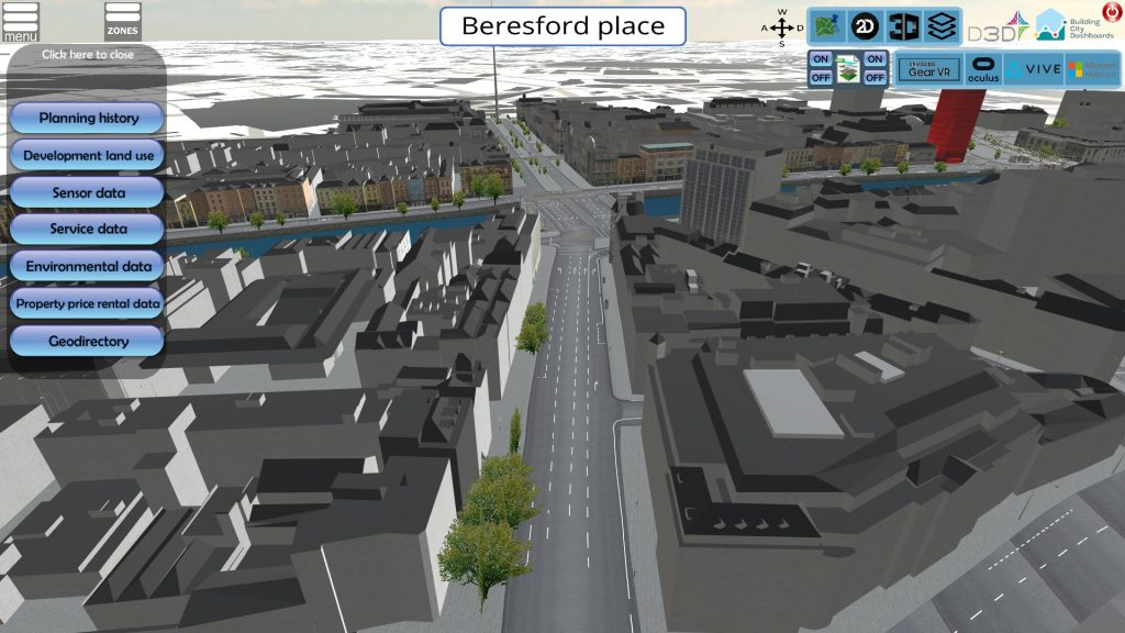
A prototype open source CIM being developed by the Building City Dashboards project This is an early stage prototype CIM built as part of the Building City Dashboards project at Maynooth University. It is developed in Unity (a games engine development software) and can be viewed through VR and AR platforms and desktop browsers.
A disruptive urban innovation?
VR, AR, BIMs and CIMs are set to be disruptive innovations in-and-of-themselves, but also as part of a wider movement towards the smart city and the deployment of a range of digital, networked technologies that increasingly mediate everyday life (most of which are heavily dependent on fine-grained geo-referenced data, such as urban control rooms, city operating systems, urban dashboards, e-government systems, predictive policing, coordinated emergency response, intelligent transport systems, logistics management, smart grids and smart meters, sensor networks, building management systems, autonomous vehicles, and a diverse set of apps). Christensen (1997) describes a disruptive innovation as one that introduces new practices, business models, and modes of governmentality that challenge and transform how a domain or system presently operates. For example, with respect to well-established city trade, the sharing economy platforms of Uber and Airbnb have reconfigured taxi and short-term accommodation markets. The rollout of disruptive innovations create what Schumpeter (1942) termed cycles of creative destruction, wherein the structures of city institutions and markets are constantly being reconfigured, displaced or destroyed through new innovations that create efficiencies and new opportunities for capital accumulation.
3D geospatial technologies are poised to reshape how cities are produced, managed, experienced, and governed by city administrations, planning consultants, construction and utility companies, and others. Their representative qualities (as 3D rather than 2D), immersive nature, and interactive spatial intelligence is starting to generate a diverse set of applications with respect to planning, city operations management, asset management, architecture, construction, policy formulation, autonomous vehicles, citizen and tourist apps, and urban play and games. In some cases, this disruption is already being realised, for example, Google Earth has had a marked impact on the GIS industry widening access to geospatial data and tools beyond institutional license-fee users to the general public; BIM is transforming how large urban developments are managed; and Pokemon Go became a worldwide phenomenon turning cities around the world into new playgrounds. In other cases, significant investment in research and development is being undertaken within universities and companies to produce new technologies, platforms, software, and data.
However, VR, AR and CIM, and other technologies reliant on 3D data such as autonomous cars, are still a few years from reaching the tipping point where their use become ubiquitous and their creative destructive potential is realised. In part, this is because the technology and its application to domains such as planning are still evolving, with affordable headsets only recently becoming available and use cases still in the experimental rather than commercial phase. In part, it is because of data issues. It is still relatively difficult to find publicly accessible, highly detailed 3D city models to use in applications. That said, a number of national mapping agencies have started to generate new national 3D data sets derived from lidar data, and there are data with variable quality available through OpenStreetMap and commercial vendors. Large corporations, such as Google and Nokia, have created or are in the process of creating global 3D datasets for a variety of projected uses, including autonomous vehicles, though these are not publicly available. In addition, there are an increasing number of project-based 3D models generated for specific purposes (e.g., asset management and urban development) by companies and city administrations. The quality, veracity and fidelity of these data is improving markedly, especially for high-value markets such as large-scale construction. In addition, 3D is an inherent aspect of producing BIMs, providing exterior and internal models of buildings. In addition, deep-rooted institutional praxes and cultures within city administrations slow technological adoption (see Kitchin et al., 2017). Planning, and local government in general, is conservative in nature and employs planning experts trained to undertake their work within disciplinary and institutional traditions. Resolving technical and data issues will inevitably drive change management in city administrations, however, given the projected benefits of 3D geospatial technology.
Politics and praxes of 3D geospatial technologies
There is a long history of social and philosophical critique of technology. Earlier waves of spatial media (e.g., GIS, geoweb, location-based services, city dashboards) and smart city technologies have been subject to critical appraisal concerning the politics and praxes of their development and workings (Pickles 1994; Greenfield 2016; Kitchin et al., 2017). Similarly, 3D geospatial applications will require critical attention as to their production and epistemology (as per critical GIS and digital geographies scholarship, see Sheppard 2005 and Ash et al. 2016) and the social, political and economic effects of their deployment (perhaps connecting with emerging work and debates on vertical and volumetric geographies, see Elden 2013; Harris 2015; Graham 2017).
As with mapping in general, and other spatial media, 3D geospatial technologies are underpinned by a realist epistemology that supposes the existence of an external reality which operates independently of an observer and that the essential qualities of the world can be faithfully captured, visualised, and analysed to reveal the world as it actually is. Moreover, as with GIS and urban dashboards, they deploy an instrumental rationality which presupposes that cities can be known and managed through a set of visual and data analytics, and that urban issues can be understood and solved through technical solutions (Kitchin et al., 2015). In this sense, they have utility because they present the world as a systematic, ordered, commonsensical form of knowledge, made even more powerful because their visual form replicates how the world appears (3D), rather than being abstracted into 2D. Moreover, they enable us to project the ‘present future’ (Adam 2004), that is to imagine the city as it might become by placing potential new buildings and infrastructure into the models, which then become the blueprints for creating that future.
As Rose et al. (2014) have argued, 3D architectural and city images are far from apolitical, commonsensical renderings, but are laden with politics and ideology designed to promote certain urban visions. Moreover, their epistemological framing is inherently reductionist, collapsing the complexity of social and spatial relations to simplified models which are generally peopleless (or at best, people are represented by avatars or agents or data points with limited parameters). Further, they ignore the metaphysical aspects of human life, and the role of politics, ideology, social structures, capital, and culture in shaping cities (Kitchin 2014). Indeed, 3D geospatial technologies generally deal with location, geo-referenced factual data, and urban form, not with intangibles, processes, and complex, multi-scalar phenomena. The danger is then, that if used in isolation, they decontextualize a city from its history, its political economy, the wider set of social, economic and environmental relations, and its wider interconnections and interdependencies.
This is not to say that 3D geospatial technologies will not be very useful as tools for planning, architecture, construction, asset management, operations management, and social policy, but that their epistemological limitations must not be elided. They should be approached in a similar manner to Critical GIS, used reflexively and in conjunction with other forms of knowledge and praxes. In this way, their utility will be realised, but in a way that compensates for their shortcomings. Regardless of such epistemological concerns, expect to be able to routinely explore and interact via VR and AR with detailed 3D renderings of the world through a variety of applications within the next decade.
Rob Kitchin is a professor and ERC Advanced Investigator at the National University of Ireland Maynooth. He is co-principal investigator of the Building City Dashboards project (funded by Science Foundation Ireland) and principal investigator of The Programmable City project (funded by the European Research Council)
Acknowledgement
The research for this article was provided by a Science Foundation Ireland grant, ‘Building City Dashboards’ (15/IA/3090).
All essays on Disruptive Urban Technologies
Gay Immigrants and Grindr: Revitalizing Queer Urban Spaces?
Andrew DJ Shield
Disruptive 3D Geospatial Technologies for Planning and Managing Cities
Rob Kitchin
What Can ‘Disruptive Urban Technologies’ Tell Us about Power, Visibility and the Right to the City?
Linnet Taylor
Published online 2018
Related IJURR articles on Disruptive Technologies
Physical Place and Cyberplace: The Rise of Personalized Networking
Barry Wellman
The Internet and Civil Society: Environmental and Labour Organizations in Hong Kong
Yin‐Wah Chu, James T.H. Tang
‘Call if You Have Trouble’: Mobile Phones and Safety among College Students
Jack Nasar, Peter Hecht, Richard Wener
‘So Long as I Take my Mobile’: Mobile Phones, Urban Life and Geographies of Young People’s Safety
Rachel Pain, Sue Grundy, Sally Gill, Elizabeth Towner, Geoff Sparks, Kate Hughes
Networking Cities: Telematics in Urban Policy — A Critical Review*
Stephen Graham
‘Tuning Out’ or ‘Tuning in’? Mobile Music Listening and Intensified Encounters with the City
Allan Watson and Dominiqua Drakeford-Allen
Urban Operating Systems: Diagramming the City
Simon Marvin and Andrés Luque-Ayala
© 2018 THE AUTHOR. INTERNATIONAL JOURNAL OF URBAN AND REGIONAL RESEARCH, PUBLISHED BY JOHN WILEY & SONS LTD UNDER LICENSE BY URBAN RESEARCH PUBLICATIONS LIMITED
This is an open access essay under the terms of the Creative Commons Attribution-NonCommercial-NoDerivs License, which permits use and distribution in any medium, provided the original work is properly cited, the use is non-commercial and no modifications or adaptations are made.